Sunday, February 26, 2006

Hey! It's not the destination, it's the voyage.


The upper level of Castillo de San Felipe with the convent in the background


A panorama of Bocagrande (left) and old Cartegena (right) from convent


Bernie (doing his David Suzuki impression) & Aysha


Jen & Dave in the mud volcanoe


Pool time with Grandma Linda

This is our 4th. day in Cartegena, mostly relaxing with Jamie, Karla and Aysha. Their apartment is located on Bocagrande, a narrow spit of land that protrudes into the Caribbean Sea in a “L” shape. Bocagrande, in conjunction with a few islands, create a natural sea wall for Cartegena Harbour. Bocagrande is a mix of apartments, hotels, houses, schools and businesses. It is one of the wealthier communities within the otherwise sprawling city of 1 million inhabitants.

Where Bocagrande meets the mainland, stands the old walled city of Cartegena. It is a wonderful example of Spanish colonial architecture. The stone wall surrounding the city took almost 200 years to complete and although damaged by attacking forces during construction, it was completed only 25 years before the Spaniards left Colombia. Except for time, vandalism and a misguided attempt to “modernize” parts of the city, the wall is intact. The old city is quite large and although touristy in parts, it is a functioning urban community. Beyond the old city, Cartegena expands into a network of seemingly disorganized roadways that are impossible to navigate unless you grew up here. (more on this later.)

Since Jamie and Karla are working Linda and I spent the first couple of days walking around the area and the old city. Naturally, taking Aysha with us when we could. Jenny and Dave decided to take a day to visit the “mud volcano” (Volcan de Lodo El Totumo), about 1 hour by bus from the city. (See photo, it tells it all!)

Saturday

On Saturday we ventured out of Cartegena to the nearby city Barranquilla. Those familiar with Latin culture will be familiar with “Carnaval” celebrations.(Mardi Gras). Well, the Carnaval de Barranquilla is the BIG carnival celebration in Colombia and Jamie suggested that we should involve ourselves in the festivities. After some investigation it was decided that the Carnaval was not a good place for babies so Karla and Aysha stayed home while the 5 of us headed out on quite an adventure.

They say that… “It’s not the destination, it’s the voyage”. Well this was a voyage like none other that I had previously experienced!

Barranquilla is located about 130K from Cartegena. To get there required a taxi ride to the bus station (30 minutes). A line up for bus tickets (45 minutes). The bus ride to Barranquilla (2 hours) and a taxi ride from the bus station to the festival area of town (45 minutes). That’s 4 hours of excitement and entertainment and we haven’t even experienced the “carnaval” yet!

Taxis, line ups and bus rides are entertainment? It is impossible to describe in words how scary and entertaining it is. I can only compare it to a carnival ride at a summer fair . . . but cheaper! As I mentioned, navigation around the city is impossible for any tourist. The city appears to be a conglomeration of smaller towns randomly situated on the outskirts of the old city. The roads, streets and lanes run in all directions and never for a great distance. The cab drivers are constantly in a hurry. It seems like a competition to get from departure to destination as rapidly as possible.

Since there were 5 of us, we took 2 cabs from Bocagrande to the bus station in Cartegena. The cab drivers followed each other, on occasion, but often took different routes in an apparent effort to get ahead of the other driver. We changed lead several time enroute to the station. The route included cutting through a couple of gas stations, passing cars on the shoulder and into the face of opposing traffic. Very entertaining.

Once we reached the festival area we first bought a beer from the nearest vendor and wandered with a moving mass of people, in the general direction of the action. The main event on Saturday is the parade of flowers but we did not know the route or when it started. We knew that to see the parade one needed to purchase tickets for the bleachers that had been erected along the route. The tickets were expensive and perhaps unnecessary, we thought, so we didn’t get them. As it turned out they were necessary if one wanted to see the parade. We did see a few of the taller floats, but it didn’t really matter. The interesting action took place in the crowded streets.

Everyone and every house in the area of the Carnaval is involved in the action. Whether it be selling food, beer, rum, aguardiente (liquorice liqueur), spray foam, water pistols, flour or souvenirs, to setting up temporary toilets for cash . . . everyone is out in the streets. Spray foam is a big seller. It is then used to spray any thing or anyone within range. Water pistols and thrown flour, accomplishes a similar effect (obviously this is not the place to wear your finest attire).

At one point we attempted to move through a constricted area behind the temporary bleaches. The crowd became tighter and tighter until we were packed together like sardines in a tin. After a few minutes we reversed direction in an attempt to extricate ourselves from the crowd. Luckily there was no panic and within 15 minutes or so we worked our way out of the constricted area. Phew!

We had been warned of the possible dangers of robbery and had taken precautions. We did not take our wallets, purses, cameras or anything else of value. My cash was secured in a zipped cash pocket located inside the top of the front pocket of my shorts (similar to the change pocket common in blue jeans). This worked well. However, Linda had some cash in the front pocket of her shorts when she entered the crowded area. It was not there when she exited the crowd! Luckily it was only a small amount of cash that went missing but the crook also stole her valuable stash of toilet paper! No big deal, we laughed about it and had another beer.

After a few hours of wandering around, watching the festivities and listening to the music we realized that it was time to think about the return trip to Cartegena. This time we caught a local bus that was eventually going to the bus terminal. We stood up for a good part of the way, literally hanging on for dear life. After a while Linda managed to get a seat. I wish I had brought a camera. A picture of Linda, sitting on a public bus, sipping beer, is just not a sight that will ever be duplicated in Canada. We lucked in at the bus depot and immediately caught the Cartegena bus for home. Back in Cartegena, all 5 of us packed into a small taxi for the ride back to the apartment where Karla had prepared supper for the voyageurs.

Sunday

Sunday, we took it easy. After breakfast we cabbed it to the highest location in Cartegena. It is the location of the Convento de Nuestra Senora de la Candelaria. A convent founded by the Augustine Fathers in 1607. Its’ prominence was of strategic importance in earlier times and was used as military headquarters after Colombian independence. It is said that one could see ships from its location when they were still 2 days from shore. Today it is once again a monastery and nicely restored.

From the convent we headed to Castillo de San Felipe de Barajas. The strongest and greatest fort ever constructed by the Spaniards. Truly impregnable, it was never taken despite various attempts. The engineering is phenomenal. It is an interesting visit. It, like the old city wall, was probably constructed with extensive slave labour. I have been told that the average life span of the slaves that were brought to Colombia was 6 months after arrival. It seems to me that possibly more people died building it, than died attacking it, but it’s just supposition. Slave labour aside for a moment, it is quite remarkable to see what can be accomplished with what must have been basic tools and manual labour.

Following our visit to the fort we returned to the apartment for lunch and relaxing poolside discussion. It is nap time now for Aysha and some of the older kids too.

Tomorrow we are off on a cruise to one of the nearby islands.

Thursday, February 23, 2006

Reached our Destination!


A hazy shot from the aircraft window approaching Cartegena. Jamie, Karla and Aysha live on the spit of land separating the ocean from the harbour... Boca Grande


This is a shot of a residential area close to the airport.

This is photo inside a cab in Panama City. How well do you think that the air bag might function?

February 23/06

We made it! Canada to Colombia... 2400K by car (4 days), 7700K by motorcycle (six weeks) and a 1 hour flight.

We had no problem getting out of Panama. The flight to Cartegena was excellent. We flew on Copa Airlines, Panama’s national carrier, The airline operation was very professional, efficient and courteous. Service was excellent. They even served a hot sandwich and free bar service on the one hour flight. Air Canada could learn a few things from Copa!

It took a while to get through Colombian customs, only because of the volume of passengers. It was great to see Jamie and Aysha waiting for us as we came out of the airport, while Karla prepared for our arrival. They had taken a cab out but we need two cabs to get us back to their apartment.

A little local knowledge always helps… in this case Jamie knew that if you walked one short block (off the airport property), the cab fair dropped from 12,000 pesos to 5000 pesos. Apparently the taxis must pay a fee to pickup on airport property. (in case you are wondering… 2000 Columbian pesos = 1C$)

After getting settled we walked up to the old city for supper. The old city looks very interesting. Can’t wait to explore it in the day time. Standby for the photos...

Tuesday, February 21, 2006

Panama City Tourists...


Freighter going through the Miraflores Locks (top row L - R, then bottom row L - R)

Dave and Joe Hummer at his shop. (sorry about the fuzzy shot)


Canadian tourists, eh!


This is the back of a local bus.... No wonder there are so many accidents!?

What do think this road sign means? Hmmm! Perhaps it just can't be translated.

February 21/06

We are still in Panama City. We are ready to fly to Cartagena, Colombia tomorrow, hopefully?

We visited the airport to speak to the customs officials about leaving the country without the motorcycles. (Our passports are stamped with a note that prohibits us from leaving the country without the MCs unless we get authorization from the customs office) At the airport there are official hospitality assistants to help English speaking tourists. We were helped by a young fellow (Javier). Calls to various customs only created more confusion. We did not explain ourselves well. Finally Javier visited the Immigration office and asked if there would be any problem with us leaving the country without the MCs. The answer he received was ..”No”. Guess we will see tomorrow??

Based on this information, we made arrangement with Joe Hummer (our mechanic) to leave our bikes with him for the week so that we could get the bikes tuned up, oil change, etc. The challenge this morning was getting the bikes to his place. There are no maps of Panama City that can be used for navigation. All we had was Joe’s address. Even when I called to ask him for directions he didn’t know where to start, but we had a plan. . . We rode to the downtown beach area. This was easy access on the toll road from our hotel. Then we hired a taxi. Linda and Jenny rode in the taxi and Dave & I followed on the bikes. Best $5. we ever spent! There was no way we have found Joe’s place without the driver. Even he had to stop and ask directions a couple of times. Joe was great. We made a list of work we needed and Joe is storing the bikes for us for the week as well as our riding gear.

After leaving Joe’s place, we hailed a cab and went to the MiraFlores Locks on the Panama Canal. Luckily a large freighter was passing through the locks as we arrived. It is a interesting operation. It cost the freighter in the pictures, just over $100K to pass through the canal. Guess it’s cheaper than going round the cape? Carlos, our next cab driver, gave us a nice tour of old Panama City and dropped us off in the downtown hotel/business area. We walked around for a while but were unimpressed with downtown Panama City and jumped a cab back to the hotel, where there is a pool and cold beer.

Hopefully, the next report is from Cartagena.

Sunday, February 19, 2006

Report From Panama City


Just another great beach. This one is Playa Santa Clara, about an hour west of Panama City


Sunrise, camping under the "ranchos" at Playa Santa Clara, Panama


Dave & Jen with the restuarant owner' s daughters at the beach near Chitre


February 17, 18/06

We are now camped at a beach near Santa Clara, Panama, only abut 100K from Panama City.

Yesterday we checked out some other beaches close to Chitre. Panama is windy country and the area around Chitre was one of the windiest areas we had encountered. We could not find suitable cabana accommodation so we ended up camping beside a beach restaurant and bar. The restaurant owners were very nice. Camping was free and the meal they prepared us was some of the best fish and shrimps that we have had. We even played pool with some of the locals and did our best to make conversation. However, there was little shelter from the wind and by morning there was a film of sand of everything… tent sleeping bags, luggage and our bodies. It makes you have a better appreciation for clean sheets.

Also I managed to stub my toe on a short, broken post. I cut my big, left toe quite badly. Getting it cleaned up and bandaged was a challenge, but it looks better today. I had to develop a heel-toe shifting technique while riding to day. I could not pull up on the shift leaver with my foot, but I could hook my heel on the shifter to up-shift.

Since our encounter with the Nicaragan police we have been careful to not-knowing break any driving regulations. However, once again we were stopped by a Panama motorcycle cop. There is a distinct lack of speed signs here, although Panama is better signed than many other countries. Sometimes you just don’t know what the speed limit is. In these cases we simply “go with the flow” and maintain the same speed as the majority of the traffic. Well apparently this doesn’t work for us either. We were told that we had passed through a built-up area at 80kph when the speed limit was 50kph. This offence occurred sometime prior to being stopped. We don’t know exactly when. I assume that the infraction was relayed by radio to this highway officer. Anyway, from my observations of Panama, I was of the opinion that the law enforcement here might be more honest then we had previously encountered. I tried to keep my cool, cooperate and explain the situation as best I could. I don’t know if it worked or not but we were only given a warning to slow down in built-up areas and sent on our way.

By noon we arrived here at the beach near Santa Clara. It is a much nicer area than we had encountered last evening. Playa Santa Clara appears to be a popular family beach with “ranchos” to rent (shade), hammocks, chaise lounges, restaurant, etc. Camping is also available for $2. per person. Except for the ants, it was great spot.

We didn’t notice the ants until we were preparing for bed. Suddenly Dave was dancing around his tent, naked and swearing loudly while slapping his legs. If he hadn’t appeared to be a significant degree of discomfort, I would have laughed at the scene. Once we had a chance to get the flashlights and investigate, we discovered that we had pitched the tents over a fairly extensive ant hill. The ants are smart enough to stay in the shade and only ventured out at night. Small tents are easy to move and the repositioning of the tents solved the ant problem.

February 19/06

We awoke at sunrise and prepared for the final southbound (actually eastbound) day to Panama City. There was no rush since we were only 100K from Panama City, but we found out that on Sunday in Panama, the beach crowd arrives early. Before 8am four guys drove up and park beside our bikes. They climbed out of their car, each with a beer in hand. You have to arrive early to rent the best rancho, I guess? After a short chat with us, “Los loco Canadienses”, they selected the preferred rancho, hung four hammocks and had a nap. By 10 am nearly all the ranchos were occupied.

After packing up, we walked to the nearest beach restaurant for breakfast and then headed for the city by late morning. Panama City is large and we wanted to get a hotel near the airport, which is located 35K on the far side of the city. This of course meant that we would have to navigate all the way across town… not one of our favourite pastimes. Our maps (hard copy and GPS) did not provide all detail that we would like.

I’ll skip all the details about getting lost, but finally we stopped at a gas station to try to get some directions. It is always interesting how fate steps in when it is most appreciated. We noticed a fellow filling up who was speaking English so we approached him for advise. It turned out he was a motorcycle rider and offered to lead us through the city centre and get us onto the “autopista” to the airport. A big thanks to “Hans”! I think it would have taken hours of frustration getting through the city.

We found a nice hotel near the airport (The Continental) and plan to stay here for 3 days. Hopefully we will be able to make arrangements with the customs officials tomorrow that will allow Dave and I to leave the country without the motorcycles. Then there is some maintenance needed on the bikes, new tire and oil change. Hopefully we get a chance to visit the canal and downtown Panama City.

Friday, February 17, 2006

Another Report From Costa Rica


February 15/06

We put in a long day today. 400K does not sound like much but on these roads, it’s a long day. From the start of the ride until we found a hotel we were on the road for 10 hours, 20 minutes. Our average speed was 38 kilometres per hour!

Perhaps my previous comments on the Costa Rica roads were a bit harsh. The roads were better today although even on the Pan-American Highway, constant attention is required to avoid the pot holes. Sides roads were still a mix of rough gravel and huge potholes. At least the gravel road we picked today had been graded and we made good progress on it.

The scenery though… is fantastic! It was a beautiful clear day. The road climbs to just over 11000 ft asl south of San Jose. The roads run along high ridges. At 8000 ft we climbed through the clouds. At 9000 ft. we were on top. (of cloud that is… for the non flying types). This only served to make the views even more glorious. Costa Rica really is a beautiful country.

There is all sorts of agriculture at these altitudes… lots of coffee. Lots of vegetation. Only at the highest altitude do the trees thin out. Otherwise the vegetation is lush and green.

Linda tells me that I am going on too much about the roads… guess I have a fixation on the pot holes, but for those of you who might want to drive (or ride) this way…..

On the highway you will often be stuck behind a line of slow moving trucks and there are very few passing lanes. The police try to control the situation by signalling trucks off the road a various locations to allow the faster vehicles to pass. Also Costa Rica police, unlike most other Central American police, have speed radar. We had been warned and not wanting another encounter with the police, we observed the speed signs. True to the warning, there were several speed radar traps. Most drivers are courteous and pay close attention to their driving (unlike most North Americans). Still some drivers are wild. They will try to drive their vehicle into what ever space it will fit. This includes passing, if they think that the oncoming traffic has enough room to move over and let him through, they will pass. In the city (San Jose today) it was the same thing. Marked lanes mean nothing. Dave and Jenny were clipped by a truck. Luckily no damage or injuries.

Enough of that! I think that we are getting used to the warm weather. I have gone back to wearing my MC jacket even under the warmest conditions. But, today at elevation, we encountered some cold weather. Even after stopping to “layer up” I was still cold. My hands were numb. I think that the temperature was below 15C. Absolutely unbearable! (right Karla?)

Due to our lack of progress we didn’t make it to the beach. We stayed a town on the highway. (San Isidro de el General) We found a nice hotel and a great restaurant.

Just an aside on the hotels here. Security is a major issue. Many of the hotels have so many bars that they look like jails. You just get used to it. On a personal note… security is not an issue unless you put yourself in risky situation. This is no different that Canada.

Tuesday, February 14, 2006

Report from Costa Rica

" Natchos as big as your ass"


February 13/06

With an early start and no more encounters with the Nicaragua constabulary we reached the Panama border fairly early. Once again the border crossing was a less than pleasant experience.

One might think that with the obstacles that one confronts at the border, that Costa Rica has not really embraced tourism. Not that this border really presented any greater challenge than the others, we just got tired of “playing the game”. We had a bit of an internal conflict at the border today. Linda and I are not apposed to paying for a service of value but Jen and Dave are of opposite mind. There are pro’s and cons to both approaches, unfortunately neither generates entirely satisfactory results. Basically this is how it appears to me… some “helpers” can and will save you time and frustration. Other however, will attempt to take advantage of your unfamiliarity and try to convince you that you need to spend more money than necessary (i.e. bribe one individual or another).

Today we encountered this situation… One official would not accept our motorcycle registration as an original. He insisted that it was a copy and it was therefore unacceptable. We had to go down the road to talk to the custom’s boss man. On the way to talk to him our helper explained that this process may take 5 hours or more, but for $30. US each (for the custom’s official) we could solve this problem. This was the breaking point for me. We emphatically state “NO, we have plenty of time. Let’s go a talk to the boss man”. To make a long story short, less than 5 minutes with the supervisor and the problem was solved. We have decided that we have figured out enough to do the process without assistance. The official customs personnel are actually quite helpful if you ask them. In a couple of days we be entering Panama.. let you know how it goes.

Note to MC travellers: The BC registration documents can be a problem at border crossings. To the Central American border personnel they do not look official enough to be genuine. Since they are computer generated forms, there is no official header or provincial seal. Any document that can easily be created with a typewriter or computer is immediately suspect.

Any way, eventually they let us into Costa Rica and we continued south on the Pan-American Highway. We decide that we should checkout the Pacific beaches so after consulting the Lonely Planet guide book we set course for Tamarindo, a popular surfing town. We had been warned, by other riders, about the quality of the roads in Costa Rica. Even a Costa Rican police officer, at a check point, warned us of the dangers of the potholes.

I have no idea why, but even the main highways have deep pot holes every so often. Constant vigilance is required. The secondary highways, that we have encountered so far, are terrible. There are large sections of rough gravel punctuated occasionally by short pieces of asphalt. Even the asphalt sections are a minefield of potholes and broken pavement. It appears that the original asphalt road has deteriorated. Instead of repairing it, the solution was to tear it up and replace the asphalt with gravel. These gravel sections are rough, washboard surfaces. The funny part is that these roads are the main access roads to the popular tourist beaches. I bet the rental car take a beating. They were the only vehicles that passed us on the rough road.

One of the reason we chose Tamarindo as a destination was because one of the restaurants advertised “Nachos as big as your ass” and we had to try them. I must say that these were without a doubt the best nachos I’ve ever had. They were a complete meal and even at Costa Rica prices, a cheap meal. (I’m pretty sure that we covered all the food groups, counting the beer of course.) Prices here in Costa Rica are, for the most part, comparable to Canadian prices. Much higher than we have been accustomed to paying. There is plenty of development here, golf courses, gated communities, fast food restaurants, etc. No wonder the locals refer to “Tamarindo” as “Tama-Gringo”. I think that we were the only ones in the restaurant this evening speaking Spanish… but we got great service.

We may stay here another day and do a long day the next day. Despite the prices, Tamarindo is worth a second look.


February 14/06 Happy Valentines Day to all you lovers!

We decide to stay here one more night. Marielos Cabinas are very nice and a reasonable price for Costa Rica ($60. / night for the 4 of us). Tomorrow we are planning a fairly long day to another beach south of San Juan. (On the way back through Costa Rica we will skip the beaches and check out the volcanoes.) Then onto Boquete, Panama then next day. We are aproximately 1200 K from Panama city now. Our plan is to reach Panama city by the afternoon of Feb 19th. This gives us a couple for days to make arrangements for the bikes and get some maintenance done.


Sunday, February 12, 2006

Still in Nicaragua


Sunset from Hide-Out Surf Camp


Sandeano leading up the trail up to the surf camp for dinner


Jenny with Shangu at Hori-zonte, El Salvador


Linda doing the laundry with monkeys (below) in trees above her.


Life's a Beach! The crowded beach at Maderra Bay


The critics of Linda's laundry technique.


February 10/06

Today was a rest day. We had been recommended a small accommodation on a small bay ½ hour north of San Juan Del Sur. Since there was no way to communicate with “Matilda’s” Dave and I road out to check on availability, while the girls looked around in town. Matilda’s has a few cabinas and a few camping spot. It is located on very nice cove beach. As it turned out the cabinas were full but we could get a camping site and one of the cabinas may be available tomorrow if we decide to stay.

Matilda’s is laid back place. Mostly young travelers here from all over the world. Like most of the places we have stayed it has a comfortable communal area where everyone congregates. Cooking facilities are available if you prefer. A fruit and vegetable guys comes by 4 times a week and if you are lucky you may be able to catch a fish or two. The road out here was a typical dirt beach road. Thankfully this one was less sandy than some of the others although it was quite rough and rutted in places. There are one or two similar accommodation operation out this way; one close by has a restaurant. The food there is OK. We spent the afternoon resting and catching up on some laundry chores.

This afternoon there were quite a few monkeys in the trees nearby. I believe that these ones are Howler Monkeys. The larger ones have a threatening howl but apparently they are not aggressive.

I’m sitting out side the tent with enough light to just be able to see the keyboard. We are miles from a city but it is quite noisy. The pounding surf sounds like constant thunder and the crickets can be heard loud and clear above the roar of the surf.

February 11/06

Another rest day at Matilda’s. We spent the day exploring the shoreline and catching up on the chores. Dave and Jenny borrowed a fishing line from a local and spent a couple of hours trying to catch our supper. No luck! As one of our fellow campers, Sandeano, stated… “Well.. that’s why they call it ‘fishing’ and not ‘catching’”.

While Jen and Dave fished Linda & I chatted with Sandeano (Real name Dean). An interesting fellow, our age, originally from LA but now residing in the San Juan del Sur area. He has been coming to this area off and on for 6 years or so and therefore a great source of local info. Since Jen & Dave didn’t have any luck with the “catching”, we had to find a place to eat. As I mentioned, the restaurant nearby was just OK but there was one other option. Sandeano suggested that we try the Hide-Out Surf Camp, located 10 minutes down the beach in the next bay.

The Hide-Out Surf Camp is a partially completed structure on a hillside overlooking the beach. It is has accommodation of sorts and a restaurant of sorts, but basically it is a place for surfers to hangout, crash, eat and surf. Anyway, to bring in a little cash, the owner cooks one dinner on a semi-regular basis for whoever shows up. (you have to check with the operator of the camp earlier in the day to see if supper is on or not) He has a regular menu. Regular in the sense that it is repetitive… Saturday it’s Spaghetti, Sunday it’s fish tacos, etc… Dinner is served sometime after sunset. It is best to make you way to the Hide-Out in time to watch the sun set. This way you can navigate the trail up the hill in daylight. Also it is a wonderful sunset viewing location.

Like most building here, the Hide-Out is open air structure. There are a few tables and kitchen located behind a bar. A sign on the wall say’s “No Service” and that is just what it means… if you want anything, you get it yourself. If you want a beer, you have to walk behind the bar to the fridge and get one. You keep track of what you take on a page in a notebook that is located on the bar. Same thing with the Spaghetti… When it was ready, a pot of sauce and a pot of steaming pasta appeared on the bar and you help you served yourself as much as you wanted. Can’t get much more casual that this and the spaghetti sauce was very good. They even had some reasonable wine on hand. We had a great meal and a fun evening.

February 12/06

We had intended to get up early, pack up and head over to Ometep today (this is a volcanic island in Lago Nicaragua) but the late night, and too much wine dictated a change in itinerary. Also the sailing times for the ferry to the island were inconvenient.

We packed up and rode into San Juan del Sur for breakfast to discuss the options. We decided that we would leave Ometep for the return trip, simply stay in San Juan del Sur another night and head for the Costa Rica border early in the morning.

Friday, February 10, 2006

Report from Nicaragua


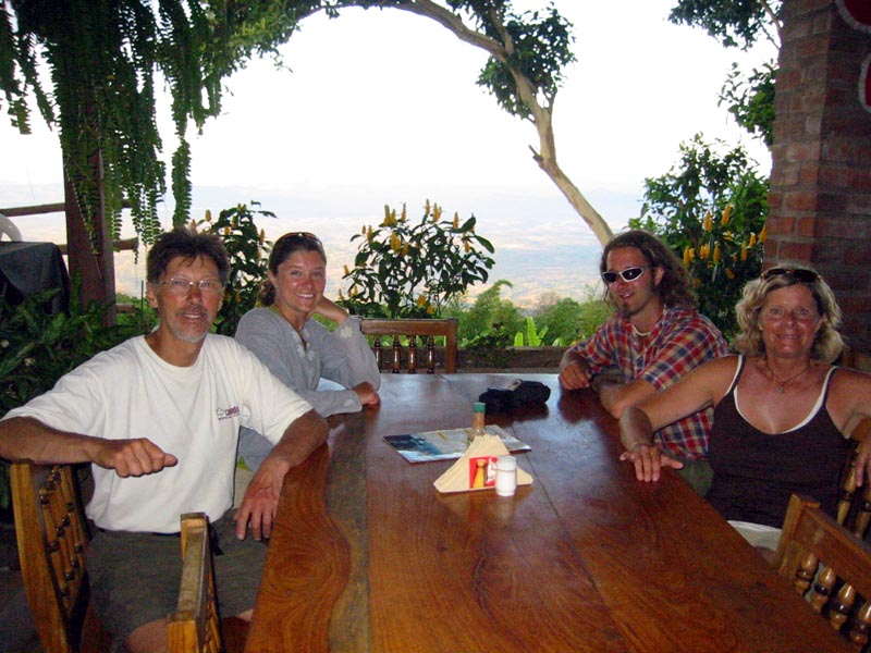
At Dinner in Alegria, El Salvador (you can't see the view in this shot but is incredible)


Dave catching a wave while in El Zonte


The coffee area arounf Alegria. The coffee plantations go right to the top of these hills.

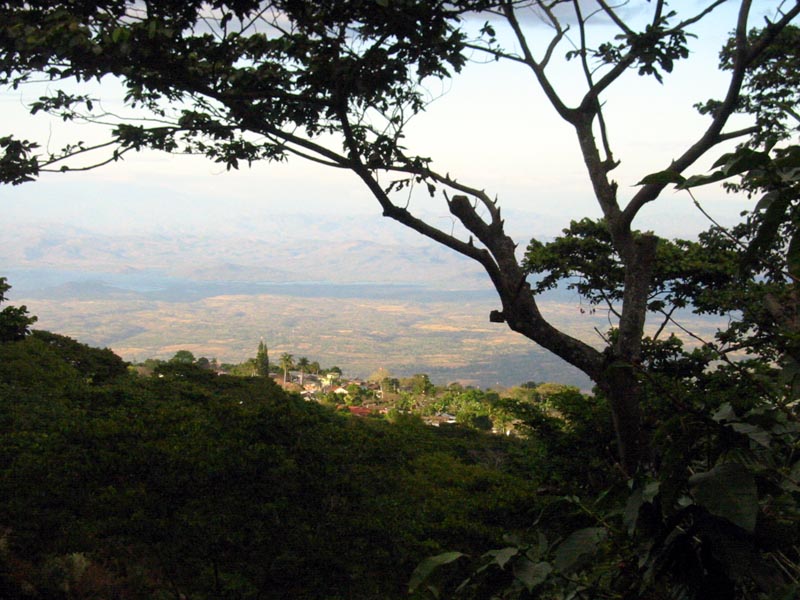
A View of Alegria from our hike to the lake.

February 7/06

Reluctantly we are leaving El Zonte this morning. We are just finishing breakfast and settling the tab. A great place and very good value. I should be keeping this place a secret!

We are heading back into the mountains again today. To a small village called Alegria (“alegria” is “joy” in Spanish). It is located about ½ way from El Zonte to the Honduras border. It is only about 150 K from here so we should have time to check out a small lake nearby that has been recommended.

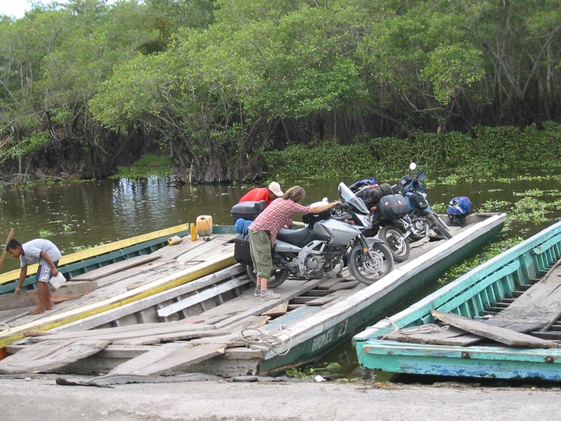
There was a choice of two routes to Alegria. The shorter route was shown on the map as a secondary highway. This is the route we decided to take. Even though it started as a gravel road it appeared to be in good shape. That is until we started climbing into the mountains. The road quickly adopted characteristics very similar to those of logging roads in BC . . . tight turns, steep grades, rutted and very dusty. We passed through two small villages on the way up to Alegria. Their rough coble stones streets were a temporary relief from the loose dusty soil of the “secondary highway”. By the time we reached our destination we and the bikes were covered in dust.

Alegria is located on high ridge in the middle of the coffee growing area. The views are spectacular. You can see most of the El Salvador and into Guatemala and Honduras from this location. It is a pretty little town. Not at all touristy. Unfortunately for us, the town square (park) is currently under renovation and is fenced off. We peeked through the fence. It looks like it will be a very attractive town centre piece when it is reopened.

We stopped at an internet café for drink and asked about accommodation. There are no “hotels” in town but several guest houses. One of these was affiliated with the coffee shop and located next door. We inquired about the location of the nearby lake and it was suggested that we hire a guide to take us up to the lake and show us around. Before we could answer, a call was made and a young fellow (18 years old) arrived at the shop. He wanted $5. to guide us for the afternoon. After discussing our options we decided to get a room and go for a hike.

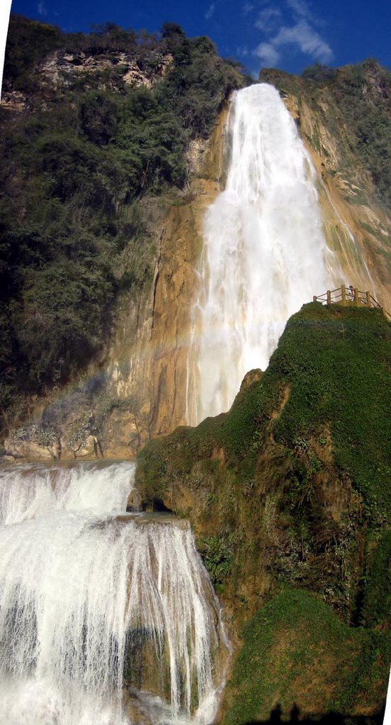
After storing the bikes in the guest house garage and getting changed we head out for “Laguna de Alegria”, a small lake in a extinct volcano crater. It is pleasant hike up coble stone roadways for about 2.5K to the lake. We walked around the lake and returned on dirt paths to town. As I mentioned the area is one of the main coffer growing areas in El Salvador. Coffee grows on steep slopes. The plants are large bushes that grow to a height of approx 3 meters. There are other taller trees growing along with the coffee plants. No machine picking here!

Our guide was a nice young fellow. He is currently attending a school to learn English and French although we communicated primarily in Spanish. Often many words in Spanish are similar to either French or English words and we could often get the drift of the explanation, even though we did not understand every word. On the way back to town he showed us a very nice restaurant with spectacular views. Since it was time to eat we invited him to join us. Once again, a very good meal and of course the obligatory beverage… cervezas.

We are now located about 2 hours from the Honduras border. We are planning and early start and we are expecting a lengthy border crossing. Where we stay tomorrow night depends on how long it takes to deal with the paperwork.

February 8/06

Happy Birthday Lee! Great talking to you the other evening.

Well, the Honduras border seemed like it was going well until the last step. We had managed to exit El Salvador with no problems or assistance (despite aggressive advances from numerous “helpers”). Customs into Honduras was no problem either. The officials were very helpful and once again assisted us with the documentation. When it came to getting the permits for the bike… that’s a different story.

We are not sure yet, whether we were conned or not, but the process we followed would be virtually impossible without guidance. We had to visit 6 offices in sequence. These offices had no names or signs! After leaving the 1st office in the sequence we hired a fellow (for $5.) to assist us. $10. with a receipt got us past the second office. (It was quite funny… when Dave gave the gal his documentation; she walked back to the card game in progress, tucked the papers under her leg and dealt the next hand.) When the hand was over we received the appropriate stamps and were on our way to the bank to pay for the permit. (approx $30. each). Then to office #3. In office 3 we were told that we needed multiple copies… 8 in total of various documents. We were also advised, by our helper, that this fellow could expedite the process for $5. each. We agreed and left for the photocopy office. We needed copies of various pages of our passport, registration, drivers licence and forms we had previously received. Now back to the previous office to complete the paper work. After sorting the papers, stapling them together and collecting 10 bucks from us, we were on our way.

Like I said at the earlier…. We have no idea if all or any of this was legitimate, but it was done and we headed down the road into Honduras.

The part of Honduras we passed through today is obviously not well off. The topography consisted of semi-arid rolling hills, practically void of agriculture. We figured that we could not get through the Honduras / Nicaragua border and then find accommodation before dark so we found a place in Choluteca, Honduras. The hotel (Santa Rosa) is OK but we are finding that the prices are high. (see note.)

***** Note: Jen, Linda and Dave just came back from the market with some food for supper. They think that we were definitely scammed on one of the money changes at the border! We think that we received 8.75 Lempiras for the US dollar. The exchange rate is 19 to the dollar! Luckily we only changed $50. US. Later I changed more money and received the proper exchange rate. We knew the rule (Know the exchange rate.) but in the confusion, we ignored it… to our dismay… next time we will be more careful. (Jamie & Karla: I don’t think my “tengo camisa negra” T-shirt help with the border crossing but I received quite a few smiles and waves from young girls…)

When we lived in Winnipeg and drove out to Fernie, we joked that if we could eliminate Saskatchewan, it would be a nicer, shorter drive. Well. Honduras is somewhat like that. You cannot avoid passing through it, if you want to go father, but it would be nice if you could. Anyway, that’s our experience.

(After re-reading this last paragraph it might seem that I am comparing Saskatchewan to Honduras. Not at all. There is NO comparison. I’m just saying that you cannot avoid Honduras if you take this route. Hopefully, Karla’s family is still speaking to us.)

We have another border crossing tomorrow. (Honduras to Nicaragua) We have heard that it is expensive one too, but we are better prepared this time. Hopefully we can put in a long day and reach south-western Nicaragua (the San Juan Del Sur area) by tomorrow evening. We plan to hole-up there for a few days doing day trips around the area.

February 9/06

We arrived in San Juan Del Sur, Nicaragua just before sunset. We had hoped to arrive a little earlier but we had a couple of run-ins with Nicaraguan officials enroute.

The border crossing went quite smoothly. We reached the border early and as we rolled up to the border area we were once again approached by money changers and potential helpers. This time we were prepared and took things in stride. We knew the exchange rate and even though the first offer was low we quickly got the rate we wanted from another changer.

It is hard not to use a helper unless you are familiar with the crossing in question. They are all different and not at all like the US/Canada border crossing to which we are accustomed. Sometimes it is hard to tell when you actually reach the border.

The helpers are pretty smooth. They simply point out where you need to start and then follow you from there. Soon you realize that you could probably do it yourself without assistance, but everything goes smoother when you have a guide. You save time and eliminate the misunderstandings that are bound to occur when there is a language barrier. Anyway all of us managed to get processed in short order. After tipping the helper $5, we were off to the Nicaragua vehicle customs. It is a couple of kilometres across the bridge separating Honduras and Nicaragua. When we reached this facility Dave and I located the correct office and the paperwork was processed.

There is usually one more checkpoint as you leave the customs area. You have to show the proper documentation to continue on. However, at this point we told we needed to buy Nicaraguan insurance. It is mandatory and it costs 210 Cordobas (about $15.). It was interesting that we were stopped at the insurance roadside stand by a uniform police officer and another fellow plus the insurance agent. Once we paid for the insurance we were told that we also had to pay each of these fellows 100 Cordoba each. We told them no problem but we needed a receipt. After a bit of mumbling and grumbling they waved us on. That was the first encounter with police today.

Our trip through Nicaragua was interesting because it was all new to us but the country side was dry and uninteresting. The only interesting feature in north western Nicaragua was the volcano that we circumnavigated. It is the dominate geographic feature in the flat dusty plains. Sugar cane is the major crop in this area. Also the road was in bad shape. The road on our map was shown as a main road (CA6) but the first 20K was a mine field of pot holes in the paved areas. The paved areas were punctuated with stretches of course gravel. Later we ran into similar conditions on another secondary highway. Nicaraguan highways certainly are the worst we have encountered so far. Even the main highways were substandard by comparison.

Nearing our destination we had another encounter with the authorities or I should say I did. There are many buses on the road here from Greyhound style to minivans. In this particular situation I was following a minivan bus on a 2 lane major highway. The minivan slowed and pulled onto the shoulder to pick up passengers. I slowed and since there was no opposite direction traffic coming toward me I gave the minivan a wide berth by moving left into the opposing lane. As I came round the mini van there were 2 cops 100 metres ahead they signalled me (us ) to stop. We stopped.

We had been warned not to give our drivers licence to a cop. Of course the first thing I was asked for was registration and licence. I showed them my licence but refused to give it to them. I produced a copy of my licence and handed it to them. They were not satisfied with this manoeuvre. Eventually I gave them my licence. I was charged with 2 offences. One was that I crossed the solid line on the highway in contravention of the highway act. The other I never did figure out.

They wrote me out a ticket then explained that my licence was to be sealed in an envelope and mailed to Managua. I would have to go to Managua and pay the fine to retrieve my licence. To make a long story short I eventually asked if I could pay the fine here and now. $20 bucks for each cop and we were on our way. (so this is $40. story).

Anyway… we have discovered since that this type of thing is a common occurrence in Nicaragua. We met 2 young guys from Saskatchewan who had received 4 tickets in 2 days… on of them was for driving a car in sandals!

The episode was no big deal but it makes Nicaragua less attractive as a tourist destination. We are planning to stay in San Juan Del Sur area for a few days of rest. Hopefully we get a better impression of Nicaragua tomorrow.

Report from El Salvador


With our host, Karol and her son, at El Zonte


Unloading the bikes from the Monerrico Ferry


The Monterrico Ferry though the lagoon


Hori-Zonte Surf Camp in El Zonte, El Salvador


More of El Zonte

Another one of the guests in El Zonte

February 4/06

Today was a pretty frustrating day. After breakfast and a visit to an internet location (there are plenty here in Antigua) we headed south for Monterrico. Monterrico is Guatemala’s Pacific playground. Even by Central American standards it is very basic.

The frustrating part of the trip happened about ½ way. We had to pass through, or around the city of Escuintla. The signs were confusing so we stopped to ask directions. We stopped at a motorcycle shop, actually a Suzuki dealership, and I went in to ask directions. I thought I understood them, but with the combination of road signs and our map, a heated discussion ensued as to which direction we should proceed. After a few minutes of discussion (argument?) I lost it. I threw down the directions I had received and stomped away saying something like… “That’s it! I’m not ever asking for directions again… etc” Of course I immediately regretted my rant, but the damage was done. To make matters worse we followed the directions I had received and it was not the correct route. There was road work in progress and after 20K the road became impassable for Linda and I. After riding back to Escuintla we eventually found the right road. Apologies over beer in Monterrico smoothed things over.

Monterrico is located on a strip of land that is separated from the mainland by a long lagoon. Short ferries are required to gain access. Unfortunately for us it was the weekend and much to our chagrin, nearly all the hotels were full. We eventually settled on an accommodation solely because it was all that was available. Aesthetically, it left a lot to be desired. We settled in and walked to a nearby beach restaurant for a bite and beer. We had front row seats for a pick up game of beach volleyball between some young local guys. It was great entertainment. These guys were quite athletic. As spectators, we became quite involved, and cheered some excellent play.

Located on the beach is a turtle sanctuary. Each evening at 5:30 they release a few young turtles to the wild. In order to raise money for the sanctuary you can adopt a turtle and perhaps win a T shirt. For 10 Quetzales (approx. $1.50) you are handed a small black turtle. Two lines are drawn in the sand, parallel to the shore, about 1 metre apart. By instinct the turtles run toward the ocean as soon as they are placed on the sand. On a command, you place your turtle on the line most distant from the water. If your turtle crosses the second line first, you win a T shirt. It was good fun, but we didn’t win.

When we returned to the “hotel” we met three fellows sitting in the “courtyard”. We joined them. Between our Spanish and their English we had a great conversation. Soon the hotel owners (a couple) started a fire and began preparing some food. To our surprise we were included in the dinner as well. It was very good. We had steak cooked over the wood fire. It had a distinctive, enjoyable smoky flavour. We talked well into the night. Even though the accommodation was marginal, the hospitality of the owners and the other guests made for a special evening.

February 5/06

Leaving Monterrico was another unforgettable experience. To gain access to the mainland we had to take another ferry. This was a 20 minute trip through crocodile (could be alligator… one or the other) swamp on a shallow draught wooden boat powered by a small outboard motor. To access the boat you had to roll the bikes up wooden planks to a rough plank decking with large gaps between them. In the waterway were areas of floating plant life. Every once in a while the prop on the motor would be come entangled in the plants and slow down. Each time this occurred the operator would raise the prop out of the water to clear it. Linda said that at first she felt like she was on “Survivor” but after we saw a water snake she commented that it now feeling more like “Fear Factor”.

Several boats are on the narrow water way at any given time so one often passes another boat travelling in the opposite direction. Friendly waves all round. Dave has discovered that the offer of a cigarette often works wonders. With a big smile the older fellow operating the boat accepted Dave’s offer. As it turned out we needed help to get the bikes back on dry land. We all had to work together to gets the bikes unloaded when we docked. It was a steep ramp and it would have been all but impossible to roll the bikes up backwards. We managed to get the bikes turned around on the boat and the three of us pushed them up to the roadway. A great adventure… all for the $10. fair.

Next stop was the El Salvador border. All in all a positive experience. As we rolled up to the Guatemala exit point we were approached by a couple of kids wanting to help us. Jen and Dave went first with the help of one of the boys. Next time we won’t need help at the Guatemala-El Salvador border. It is a pretty straight forward procedure. If you have copies of your passport it helps but you will probably have to get Guatemala vehicle permit copied as well. Essentially you have to “exit” (salida) yourself (passport stamped at one office) then “exit” your bike at another. Between these two is a trip to the photocopy person. At this border crossing (on CA2) they were all in close proximity.

When this is complete you head off down the road about a mile to the El Salvador Aduana facility. As we approached this facility we were stopped at a gate and asked to produce our passports and the Guatemala exit documentation. We were then directed to a parking area. Once again there are two offices to visit and forms to complete. (Tourist visas cost $10 US per person.) Here having copies of your passport and vehicle registration saved a trip to the photocopy guy. The El Salvador officials were very helpful. There are signs in the vehicle entry office indicating that there are no fees for the vehicle permit and that you do not need to pay anyone to help you. Both of these were true, the officials were pleasant and helpful . . . to the point of filling out parts of the form for us.

You could be through the border in less than an hour but it took us a couple of hours since we did not want to leave the bikes unattended and could not be processed simultaneously. Perhaps we were too cautious, but better safe than sorry. Oh yes, one other thing. You need a destination in El Salvador in order to get a tourist visa. They would not accept Panama as our destination. Apparently the computer would not accept “Panama”. As luck would have it there were some other Canadians at the border as well. They had just given us a recommendation for a place to stay and the card for a hotel. We used this as our destination in El Salvador, both the official and his computer were happy with that (us too). Paperwork complete we gassed up and head for the recommended destination about and hour and a half down the road.

Our destination was a surfing beach called Playa El Zonte. It was not even on our map so undoubtedly we would have missed it had we not met the other Canuks. The recommended hotel was full but another just across the street was very nice. It is called Hori-zonte Cabins and we highly recommend it. Nice, clean, air conditioned cabins, beautiful grounds, swimming pool, beach restaurant, friendly owners. There is a central communal area with a fridge and stereo. The fridge is stocked with beer, pop, juice and water. It is serve yourself on the honour system. Each day you start a page. Put your name on the top and keep a total of what you took from the fridge. They are not minibar prices either . . . $1.00 for beer, less for pop. We are planning to stay here for a couple of days. Tomorrow we plan to rest up, rent a couple of boogie boards and hit the waves.

February 6/06

Having a great day relaxing in ELZonte. We rented a couple of boogie boards from the hotel and each gave it a try. Dave managed to catch a good wave but the rest of us just got tumbled around in the waves. The bay here is about 1 kilometre wide. The surf comes into the bay at an angle. This creates a rip tide on the opposite side of the bay. I recognized the problem my first time out. I noticed that I had difficulty getting back to shore. The second time I went out, Linda came with me. We talked about the rip tide as we waded into the ocean. I reminded her to stay close to shore but before long, Linda was sailing for Australia on boogie board. I paddled out to help and with additional assistance from a local surfing guide (Walter) and his companion, we worked our way back to shore. Needless to say… Walter was our guest for beer this afternoon.

This hotel is quite special. It would be great place to come for a week or two. You can fly from LA for under $400. and it is a $25. cab ride from the airport. It is quite easy to arrange for a ride or catch a bus to San Salvador for the day. El Salvador uses the US$ for its currency so it is easy to bring cash. However, getting cash in El Salvador is difficult or so we are told. The only bank that has a cash machine is in San Salvador. And as luck would have it, we are running low on cash. In the level of hotel we have used, credit cards are useless. If you came here you might as well leave the credit cards at home. (Later Edit; Actually we found a bank with an instant teller while passing through a town between El Zonte and the Honduras border. Can’t remember the town right now)

Saturday, February 04, 2006

Report From Guatemala


January 31/06

Another short day today. Under 100K to El Chiflon. El Chiflon is a spectacular waterfall about 40K south-west of Comitan de Dominguez. The location was recommended to us by Dan (a Canadian owner of a restaurant in Puerto Escondido). Stopping here fit well into our travel plans since it is less than 100K from the Guatemala border crossing at La Mesilla. We had planned to camp here. Camping is available but it is not suited to MC travel since you have to walk in about 200 metres from where you must leave the bikes. However, cabanas are available also and you can park the bikes on the porch of the cabanas. The cabanas for the four of us cost us $40. The park entry fee is $1. per person. We were not sure if food would be available here so we stopped at a grocery store in Comitan for supplies. For $6. we bought enough food for dinner and breakfast tomorrow.

The walk to the falls from the cabana is just over 1K along the river back on a nicely prepared stone and concrete walk and stairs. The falls really are quite spectacular. The water is a turquoise green colour. We were told that the water colour was caused by the high calcium content. It was also great to get a bit of exercise.

The ride today started out quite cool and there was a threat of rain in the high country. By the time we reached El Chiflon we had descended to 2500 ft. and the temperature was once again quite warm.

We passed several military checkpoints today... more that usual. We have not been stopped at any of the checkpoint yet. We noticed as we came father south that security seems more visible. A few days ago we started to notice armed guards at the Pemex gas stations. These fellows are uniformed and carry automatic rifles. We have been told that in the Central American countries we can expect to see many more guns.

Time to play a bit of cards before bedtime. Tomorrow an early start for the Guatemala border. Our destination for tomorrow night is Huehuetanango. (pronounced way-way-ten-an-go).

February 1/06

On The Way To Hueheue…

We reached the Guatemala border just before 11 am. The border is a confusing mix of shops, money changers, customs officials, border guards, tourists etc. There are vehicles of every description… tourist buses, private cars, local buses, trucks, pedestrians, etc. all moving two ways on a street just wide enough for two cars. It is difficult to determine if you have reached the border or in which country you are currently located. We simply stopped riding when it seemed like we should be talking to someone. Someone eventually approached us and told us we need to get our vehicles sprayed for agricultural purposes. This we did. Paid the 15 Quetzales and were told to report to the Aduana (customs). {Note: we had expected that we would be swarmed with kids wanted to assist us with our progress through the customs process. This did not occur. There was no assistance evident.}

In customs we were told that we did not have the necessary stamps (in our passports) from the Mexican “Migracion” and we would have to return 4K into Mexico to get the required stamps. (We later learned that we must exit (salida) each country before we enter (migacion) the next.) While we were waiting for this information we managed to change some US$ and Pesos into Quetzales from a local money changer.

After returning the 4K back to the Migracion office and returning to the Guatemala Aduana we quickly received the necessary paper work and stamps. Then we were directed to another office to complete the paperwork for the bikes. 37 Quetzales late we were on our way. All in all it took about an hour to get through the border. Not bad considering we had to go back to get the Mexican stamps.

Once in Guatemala we navigated the traffic though the border town and onto CA1 the highway to Huehuetenango. We had be briefed that we would immediately notice that Guatemala was a poorer country that Mexico… may be we missed something, but this was not our impression. Border towns are border towns. They are what they are and not necessarily indicative of the norm. Once outside the town were impressed by the cleanliness and the amount of newer construction.

As soon as you enter Guatemala you are immediately into the mountains. The scenery is wonderful. The road, for the most part is windy and smooth. There was some evidence of the recent mud slides but road repairs were virtually completed. Habitation is built high up the slopes. There does not appear to be road access to these homes. Every so often there are walking trails that come down to the highway. Most locals commute by bus. There are buses of every shape and size as well as an abundance of taxis. The larger buses here are painted bright colourful ways. Make’s you smile every time you see one… unless it is in your rear view mirror a metre or so from your rear wheel!

We reached Huehue by 2:30 pm and made our way to the “Centro” (center of town). Generally this is the location of the hotels, restaurants etc) Thanks to our Lonely Planet book we located a hotel near the centro. We discovered that it may be cheaper for us to get 2 rooms than 1 room for the 4 of us. In both hotels we checked today they charged by the person. Same price, one room or two. In this hotel we have one room with a bathroom and shower and the other with no bathroom for less money than one room with a bathroom. Seems like a good deal to us… we all still use the same bathroom but we have more space and separate rooms. After checking in and getting cleaned up we went out looking for a bite to eat.

Sometimes language is not a huge problem. Sometimes it is. This was on of those times. In the first restaurant, we did manage to get a beer but that’s all! Even after I ran back the hotel to get the dictionary and phrase book we could not figure out what the restaurant had to offer. Perhaps too, our timing was wrong…the restaurant appeared on the verge of closing. When they had stacked the chairs on every table but ours, we decided it was time to leave.

The second restaurant experience was much better. Great pizza and more beer. (Does it seem to you that we might be drinking too much beer?) Anyway… This restaurant (Don Juan’s) had a good breakfast menu too so it looks like we will be going back in the morning.

Tomorrow we are continuing down Hwy CA1 Xela. We are planning short days through Guatemala so that (hopefully) we will have more time to see some sights that are off the highways. There is suppose to be some good hiking in the area we are heading.

February 2/06

Up early today and luckily the restaurant we had chosen for breakfast appeared to be the only one that was open at 6:30. We were on the road before 8 am.and it was quite cool. So cool in fact that we soon had to stop for warmer clothes. We started riding at about 6000 ft. and climbed to just over 10,000 ft. We were in the clouds at this elevation. The scenery and the road are both wonderful. You are in steep mountainous terrain although it is quite different that at home in BC. The mountains are treed to the top and so is the agriculture. The cultivated fields are extremely steep. It is obvious that all the work is done by hand or with oxen. Many of the fields are far too steep for machinery.

We had planned to go to a hot spa near Quezelatenango but enroute we stopped for gas and talked to a fellow who owned a BMW. He suggested two other locations so we changed our plans. We rode to the small village of Chichicatenango. It was billed as an authentic Mayan village. It was but the Mayan here have discovered that tourism pays better then farming. We learned that when someone offers you a service, ask how much it is going to cost before you accept the service. A local asked us if we wanted her to show us the local church. We accepted the offer and after a very nice but short tour we where told that we must pay 50 Quetzals.. blunt and to the point.

The best part of going to Chichicatenango was the ride there. These towns are located along narrow mountain ridges. For of those of you in Fernie… it is you are riding a road along the top of Morrisey ridge. The interesting part is getting up onto the ridge. Some turns are so sharp and steep that they are negotiated in 1st gear because the turn is so tight and with almost full throttle because it is so steep.

From Chichicatenango we back tracked down to Panajachel on Lago de Atitlan (a collapse volcano lake) This is one of the oldest tourist area in Guatemala. Unfortunately the visibility was poor today and we could not see the active volcano on the far shore.

As we were getting moved into the hotel we met a fellow from Kelowna who was on his way back from Panama City with his wife on a BMW RT1200. We made arrangement to meet for beer. The beers turned into dinner and we had a nice evening trading travel stories. We picked up some good pointers from Dan and Bonnie. They had been on the road since October and were making their way homeward now.

February 3/06

The visibility was a little better this morning and all 3 volcanoes were visible from the lake shore. Only one of them is currently active. After breakfast we loaded up and headed for Antigua. We decided to take a minor paved road rather than the busier highway. It was good choice. The road climbed high above the lake and the views were spectacular. There was road work in progress all along this route due to the recent mud slides. Some parts of the road had been destroyed so the were a few detours as well.

As I mentioned earlier, the mountains here are treed to the top. I’m not a geologist so I don’t know much about rock formations, etc. but from observation of the mud slides and the road cuts through the hill sides that there does not appear to be much solid rock. The roads appear to be cut out of the clay bank. It is easy to see how mud slides would be prevalent in this steep terrain in times of heavy rain.

Antigua is an old but well preserved colonial city (from the Spanish colonization). A local told us that it was to be the capital but the Spaniards abandoned it and moved the capital to Guatemala City because of the number of earth quakes in this area.It appears to have survived the earth quakes quite well as most of the larger buildings and churches are reasonably well preserved. The town square with fountain and trees is very attractive. The city still has retained the coble stone streets. (They can be tricky on the bike, especially when wet.) Antigua is becoming a trendy tourist area and there are an abundance of nice hotels and restaurants. It has also developed a reputation for Spanish language instruction and there are several schools and family operated businesses that cater to those wishing to learn Spanish.


We are headed toward the
El Salvador border this morning but we may spend another day in Guatemala depending on our progress. We are planning to spend an extended rest stop in Nicaragua. All is well… having a great time. Not missing the snow at all!